
Log Yard Campground
A Park Service backcountry campground and year-round boat ramp at River Mile 37 on the Current River: six reservable sites, a vault toilet, and some of the darkest night skies in the park.
Your Guide to the Ozarks
Some places stay quiet even in July: the spring at the end of the gravel road, the overlook nobody signs well. These are the guide's low crowd places, for when the point is the quiet itself.
A Park Service backcountry campground and year-round boat ramp at River Mile 37 on the Current River: six reservable sites, a vault toilet, and some of the darkest night skies in the park.
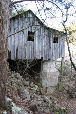
Walter Klepzig's little turbine mill still stands in the shut-in canyon of Rocky Creek, unsigned and easy to pass by, at the end of a dirt road or a hike from Rocky Falls.
A 95-acre natural area where a dolomite bluff rises about 500 feet above the Current River, split between the Park Service and the Conservation Department, met best from a float down from Powder Mill or a map-and-compass walk along the bluff top.
A small, quiet conservation lake east of Van Buren with a concrete ramp for electric-motor boats, a mile-long trail around the water, picnic areas at two parking lots, and bass, bluegill, catfish, and redear sunfish.
Missouri's elk country: a roughly 23,000-acre conservation area near Winona with a self-guided elk viewing driving tour that starts at the area office, a viewing deck over a beaver pond, primitive camping, Ozark Trail miles, and four natural areas, at the end of about seven miles of gravel road.
A 31-acre Forest Service fishing lake just off Highway 60 west of Ellsinore, with a barrier-free floating pier, a single-lane concrete ramp for electric-motor boats, a flat 1.3-mile trail around the water, and a picnic pavilion that holds groups of up to 75.
A 288-acre natural area on the lower Current River with old-growth sycamore bottomland and a natural dolomite arch in the east-bank bluff, reached on foot from a signed pull-off on Forest Service Road 3140 west of Grandin, or by floating across from Gooseneck.
Missouri's second largest spring bursts from a cave mouth and a boiling stream bed at the bottom of a wooded ravine, reached by a 0.9-mile trail off Highway 19, then runs 1.25 miles to double the Eleven Point River.
A spring pours from a cave opening in a bluff and drops about 15 feet into a millpond beside a small 1927-1929 mill and an 1851 log homestead cabin, in a rustic Forest Service picnic ground south of Winona.
A 25-foot steel mill wheel stands in the branch of Turner Spring on the north bank of the Eleven Point River, with a day-use picnic area and launch on the north side and a rustic campground and concrete launch facing it across the water.
More than 38,000 acres of oak, hickory, and shortleaf pine in scattered Shannon County tracts, introduced by a five-mile driving tour through a pine-oak woodland restoration project south of Eminence, with nine miles of the Ozark Trail and primitive camping.
A small Park Service campground and river landing on the Current River at the Highway 106 bridge: eight basic sites in an open field, a year-round restroom, and trails running to Blue Spring and the Ozark Trail.
A closed cave with an open threshold: a short path from a Highway 106 pull-off leads to the entrance of a nearly nine-mile cave, where a spring branch runs out of the dark and endangered Indiana bats spend the winter.