
Klepzig Mill
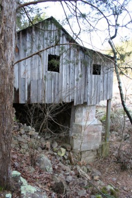
Walter Klepzig's little turbine mill still stands in the shut-in canyon of Rocky Creek, unsigned and easy to pass by, at the end of a dirt road or a hike from Rocky Falls.
Get directionsOpen in Google Maps
Walter Klepzig, a German immigrant farmer, built a small turbine mill on Rocky Creek in the early 1900s (the National Register nomination dates the mill to about 1912) and moved it to its present spot on the creek's steep south bank around 1928. The building is a sawmill house in the local sense: vertical boards nailed straight to top and bottom sills, with a concrete spillway, a forebay, and a door hinge said to have been cut from a Model A Ford hood. The Park Service stabilized the mill in 1987, and it survives as the centerpiece of the 121-acre Walter Klepzig Mill and Farm district, added to the National Register of Historic Places in 1990.
Nothing here is developed for visitors, and that is the appeal. There is no sign and no real parking area. From Highway NN, County Road 522, a dirt road that can run muddy and narrow, passes within a short walk of the mill, less than a mile in. Hikers can also follow the Ozark Trail over from Rocky Falls. Go expecting a quiet ruin in a rocky canyon, not an attraction with facilities.
Good to know before you go
- Fees
- No fee is stated. No entrance pass is required anywhere in Ozark National Scenic Riverways.
- Hours and seasons
- No seasonal closure or hours are stated by the official sources.
- Parking
- No sign or defined parking area (NPS). Visitors park along County Road 522 or at the end of the pavement on Highway NN and walk in. Reaching it: Highway H to Highway NN (east of Eminence and Winona), past the Rocky Falls sign, then left on County Road 522; the mill is less than a mile down the dirt road, on the right. The road can be very muddy and narrow and is not recommended for large motorhomes or trailers. Hikers can also follow the Ozark Trail from Rocky Falls.
- Accessibility
- No accessibility statement is published for this site; the approach is an unpaved road and an unsigned stop with no developed facilities.
- Nearest town
- Winona, Missouri
- Region
- Southeast Missouri
- Coordinates
- 37.126563, -91.198387